


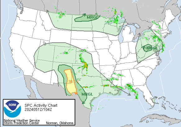
| WASHINGTON DC METRO AREA FORECAST DISCUSSION High pressure will move offshore through Wednesday. A cold front will approach from the Midwest late Wednesday, then cross the northern Mid-Atlantic Thursday. The front will stall to the north across Pennsylvania keeping the local area in a warm and humid air mass through early next week. |
Current DC Area Radar & North America Lightning
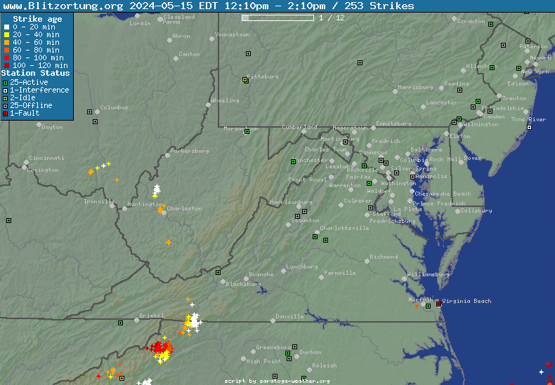
Northeast US Radar
|
North America Lightning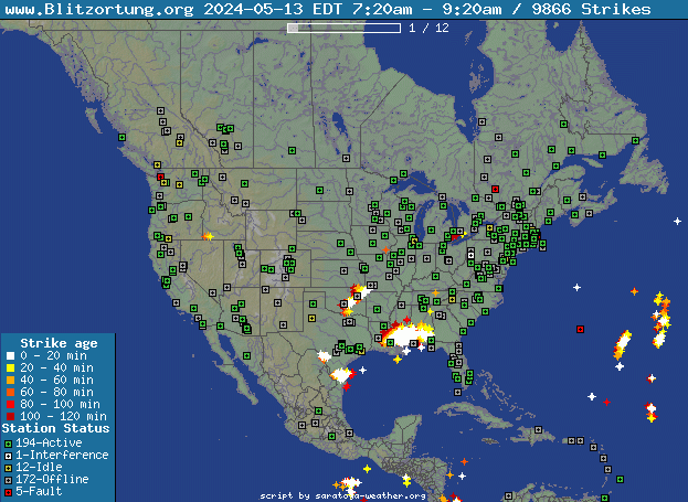
|
| Radar image courtesy of NWS. | Lightning Data courtesy of Blitzortung.org and its Contributors. |
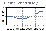
Current Clifton Virginia Conditions & NWS Forecast
| Updated: @ 21-May-2024 8:30am - next update at 8:40am | ||||||||||||||||||||||||||||||||||||||||||||||||||||||||||||||||||||||||||||||||||||||||||||||||||||||||||||||||||||||||||||||||||||||||||||||||||||||||||||||||||||||||||||||||||||||||||||||||||||||||||||||||||||||||||||||||||||||||||||||||||||||||||||||||||||||||||||||||||||||||||||||||||||||||||||||||||||||||||||||||||||||||||||||||||||||||||||||||||||||||||||||||||||||||||||||||||||||||||||||||||||||||||||||||||||||||||||||||||||||||||||||||||||||||||||||||||||||||||||||||||||||||||||||||||||||||||||||||||||||||||||||||||||||||||||||||||||||||||||||||||||||||||||||||||||||||||||||||||||||||||||||||||||||||||||||||||||||||||||||||||||||||||||||||||||||||||
| Temperature | Summary | Outlook | ||||||||||||||||||||||||||||||||||||||||||||||||||||||||||||||||||||||||||||||||||||||||||||||||||||||||||||||||||||||||||||||||||||||||||||||||||||||||||||||||||||||||||||||||||||||||||||||||||||||||||||||||||||||||||||||||||||||||||||||||||||||||||||||||||||||||||||||||||||||||||||||||||||||||||||||||||||||||||||||||||||||||||||||||||||||||||||||||||||||||||||||||||||||||||||||||||||||||||||||||||||||||||||||||||||||||||||||||||||||||||||||||||||||||||||||||||||||||||||||||||||||||||||||||||||||||||||||||||||||||||||||||||||||||||||||||||||||||||||||||||||||||||||||||||||||||||||||||||||||||||||||||||||||||||||||||||||||||||||||||||||||||||||||||||||||||
|
|
|
||||||||||||||||||||||||||||||||||||||||||||||||||||||||||||||||||||||||||||||||||||||||||||||||||||||||||||||||||||||||||||||||||||||||||||||||||||||||||||||||||||||||||||||||||||||||||||||||||||||||||||||||||||||||||||||||||||||||||||||||||||||||||||||||||||||||||||||||||||||||||||||||||||||||||||||||||||||||||||||||||||||||||||||||||||||||||||||||||||||||||||||||||||||||||||||||||||||||||||||||||||||||||||||||||||||||||||||||||||||||||||||||||||||||||||||||||||||||||||||||||||||||||||||||||||||||||||||||||||||||||||||||||||||||||||||||||||||||||||||||||||||||||||||||||||||||||||||||||||||||||||||||||||||||||||||||||||||||||||||||||||||||||||||||||||||||


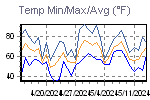
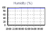
| Trends | |||||||||||||||||||||||||||||||||
| |||||||||||||||||||||||||||||||||

| NWS Weather Forecast - Outlook: Today & Tonight | ||||||
|
||||||
| NWS Weather Forecast - Five Day Outlook for Today through Saturday - Last Update: Tue, 21-May-2024 7:29am EDT |
|
Today Patchy Fog then Mostly Sunny |
Tonight Mostly Clear |
Wednesday Mostly Sunny then Slight Chance Showers And T-Storms |
Wednesday Night Slight Chance Showers And T-Storms then Mostly Cloudy |
Thursday Mostly Cloudy then Showers And T-Storms Likely |
Thursday Night Showers And T-Storms Likely |
Friday Chance Rain Showers then Chance Showers And T-Storms |
Friday Night  Chance Showers And T-Storms |
Saturday Showers And T-Storms Likely |
| Hi 83 °F | Lo 61 °F | Hi 88 °F | Lo 68 °F | Hi 85 °F | Lo 65 °F | Hi 83 °F | Lo 64 °F | Hi 79 °F |
NWS Forecast Maps
NOAA Forecast Map for Today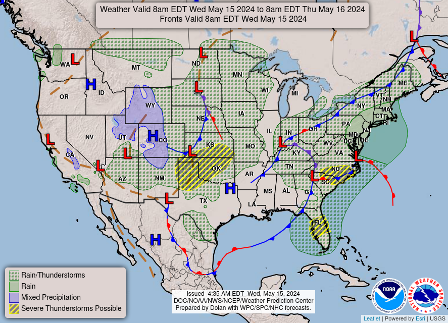
|
NOAA Forecast Map for Tomorrow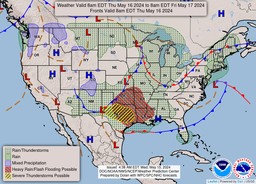
|
| Forecast map for Today courtesy of NOAA. | Forecast map for Tomorrow courtesy of NOAA. |
Random Weather Facts
|
Clouds Mostly sunny and mostly clear indicate the same amount of cloud coverage - about 25 percent. Mostly sunny is used during the daytime, and mostly clear is used at night when there is no sun. |
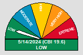
Today in Weather History
|