Flood Warning FLOOD WARNING - Fairfax Cnty, VA  - Loudon Cnty(E), VA  - Loudon Cnty(W), VA  - Montgomery Cnty(C+SE), MD  - Montgomery Cnty(NW), MD  - Washington, DC
Coastal Flood Advisory COASTAL FLOOD ADVISORY - Alexandria, VA  - Arlington Cnty, VA  - Falls Church, VA
Test Message TEST MESSAGE - Montgomery Cnty(C+SE), MD  - Montgomery Cnty(NW), MD

WASHINGTON DC METRO AREA FORECAST DISCUSSION
A warm front is expected to lift through and to the northeast of the region today into late afternoon. A low pressure system will move into the Great Lakes today with a trailing cold front pushing through the area on Saturday. High pressure will build in from the north Sunday and Monday.

Current DC Area Radar & North America Lightning


Northeast US Radar


Regional Radar

North America Lightning


North America Lightning Strikes
Radar image courtesy of NWS. Lightning Data courtesy of Blitzortung.org and its Contributors.
spacer

Current Clifton Virginia Conditions & NWS Forecast

Updated: @ 16-May-2025 12:10pm - next update at 12:20pm  
Temperature Summary Outlook
Currently: 86.5, Max: 86.5, Min: 67.2 86.5°F
Warmer 5.1°F than last hour.

Warm

Feels like: 95°F

24-hr difference
9.4°FWarmer 9.4°F than yesterday at this time.
  Today Yesterday
High: 86.5°F
12:05pm
83.7°F
3:37pm
Low: 67.2°F
6:29am
64.5°F
6:19am
High & Low May 2025
High:  87.5°F
02 May at 3:13 PM
Low:  44.2°F
10 May at 6:56 AM
Max Min:  66.7°F
02 May
Min Max:  65.6°F
09 May
High and Low 2025
High:  87.5°F
02 May at 3:13 PM
Low:  7.4°F
23 January at 6:32 AM
Max Min:  69.0°F
30 March
Min Max:  22.4°F
21 January
Record May
High:  93.7°F
at 15:47 on 31 May 2022
Low:  32.0°F
at 03:46 on 10 May 2020
Max Min:  72.0°F
at 23:59 on 27 May 2015
Min Max:  51.3°F
at 14:37 on 09 May 2020
Station All Time Record
High:  101.9°F
at 15:51 on 02 August 2024
Low:  1.0°F
at 07:23 on 23 January 2014
Max Min:  78.1°F
at 06:58 on 23 June 2024
Min Max:  16.7°F
at 12:04 on 16 February 2015
Records began on 24 December 2012
Wind Chill
Now:  86.5°F
Coldest Wind Chill
Today:  67.2°F
at 6:29am
Yesterday:  64.5°F
at 6:19am
May 2025  44.2°F
10 May at 6:56 AM
2025  -3.6°F
22 January at 6:58 AM
Station May  27.4°F
at 07:06 on 09 May 2020
Station All Time  °F
Records began on 24 December 2012
Degree Days
Heating Degree Days
Today: 0.0 Degree Days
Yesterday: 0.1 Degree Days
Cooling Degree Days
Today: 3.4 Degree Days
Yesterday: 7.3 Degree Days
Heat Index
Now:  93.7°F
Warmest Heat Index
Today:  95.4°F
at 12:06
Yesterday:  88.4°F
at 15:42
May 2025  95.4°F
16 May at 12:06 PM
2025  95.4°F
16 May at 12:06 PM
Station Record May  105.0°F
at 13:55 on 26 May 2021
Station All Time  122.8°F
at 14:48 on 16 July 2024
Records began on 24 December 2012
WeatherCam Thumbnail
North North West Camera
North North West WeatherCam
Few Clouds Few Clouds
 Wind from NNE NNE
1
Gust:
4 mph
0 Bft - Calm
Today: 5 mph 10:56am
Gust Month: 18 mph May 5
Rain Today:  0.00 in
Rain Rate /hr  0.00 in
Rain Last Hour:  0.00 in
Rain 24hrs:  0.00 in
Wind

Station High May 2025
High Gust:  18 mph
05 May at 7:17 PM
High Average:  5 mph
05 May at 7:22 PM
Station High 2025
High Gust:  27 mph
01 March at 2:22 PM
High Average:  11 mph
31 March at 9:02 AM
Station Record May
High Gust:  27 mph
at 15:33 on 26 May 2017
High Average:  15 mph
at 14:07 on 08 May 2016
Station All Time Record
High Gust:  42 mph
at 12:56 on 04 January 2018
High Average:  24 mph
at 13:07 on 02 March 2018
Records began on 24 December 2012
Wind Run

Today:  3.6 miles
Yesterday:  8.3 miles
Highest Wind Run
May 2025  34.8 miles
13 May
2025  93.0 miles
16 March
May  139.2 miles
on 13 May 2015
Station All Time  284.2 miles
on 02 March 2018
Records began on 24 December 2012

Rain
Rain Today: 0.00 in
Rain Rate (/hr): 0.00 in
Rain Yesterday: 0.01 in
This Month: 3.40 in
Season Total: 12.87 in
1 day since last rain.

Days Since Last Dry Day: 4
Station High May 2025
High Day:  1.51 in
13 May
High Hour:  0.57 in
09 May at 2:00 AM
High Rain Rate /hr:  3.02 in
09 May at 1:31 AM
Station High 2025
High Day:  1.53 in
21 April
High Hour:  0.57 in
09 May at 2:00 AM
High Rain Rate /hr:  6.26 in
26 April at 2:43 PM
Station Record May
High Day:  2.46 in
on 31 May 2018
High Hour:  2.16 in
at 18:26 on 31 May 2018
High Rain Rate /hr:  7.29 in
at 20:36 on 26 May 2021
Station All Time Record
High Day:  5.17 in
on 21 July 2018
High Hour:  2.21 in
at 16:13 on 22 July 2020
High Rain Rate /hr:  64.00 in
at 10:49 on 19 October 2021
High Month:  10.27 in
July 2018
Records began on 24 December 2012

WeatherCam Thumbnail
South South West Camera
South South West WeatherCam
This
Afternoon
This Afternoon: Scattered Showers And Thunderstorms
Scattered Showers And T-Storms
Tonight

Tonight: Chance Showers And Thunderstorms
Chance Showers And T-Storms
Saturday

Saturday: Chance Showers And Thunderstorms then Slight Chance Showers And Thunderstorms
Chance Showers And T-Storms then Slight Chance Showers And T-Storms
Hi 89 °F Lo 66 °F Hi 85 °F
Lightning VA MD DC WV DE

Viginia Lighting
Radar Washington DC Metro Area

  GRLevel3 radar from NWS station KLWX

Storm Prediction Center Activity Chart

SPC Activity

Humidity & Barometer
Humidity: 64 % Decreased 13.0% since last hour.
Dew Point: 72.9°F Decreased 2.7°F since last hour.
Barometer: 29.74 inHg Falling 0.01  inHg/hr
Baro Trend: Falling slowly
Today
Pressure High:  30.09 in
Pressure Low:  29.99 in
Dewpoint High:  33.1 °F
Dewpoint Low:  19.6 °F
Humidity High:  80%
Humidity Low:  40%
Station Record
Pressure High:  31.41 in
at 12:14 on 23 March 2017
Pressure Low:  28.99 in
at 07:41 on 07 February 2020
Dewpoint High:  82.7 °F
at 11:55 on 05 July 2024
Dewpoint Low:  -27.0 °F
at 01:57 on 20 February 2015
Records began on 24 December 2012
Snow

Snow Depth: 0.0 in
Snowfall Today: No Snow Today
Storm Total: 0.0 in
Total Season Snow: 15.5 in
Total Last Season: 10.0 in
Fire Danger
firedanger
Almanac
Sunrise: 5:54am
Sunset: 8:17pm
Moonrise: 12:00am
Moonset: 8:27am

Day Length:  14:19
Dawn:  05:26
Dusk:  20:46
Daylight Length:  15:20
 There will be 1min 42s more daylight tomorrow

Cloud Base

cloudbase
CB AGL: 3097 ft
UV Index

   6.5   
 High 
High: 6.5 @ 12:06pm

Solar Radiation
895 W/m2
High: 914 @  11:55am

Air Quality Index
Current AQI
68
  Moderate

Sunlight

14 hrs 23 min 12 sec
of Sunlight Today
Which is
1 min 45 sec Longer
Than Yesterday

(Noon)
graph (Midnight)
Legend

Moon


Waning Gibbous
Waning Gibbous, Moon at 18 days in cycle
86% %
Illuminated
 NWS Weather Forecast  - Outlook: This Afternoon & Tonight
This
Afternoon
This Afternoon: Scattered Showers And Thunderstorms
Scattered Showers And T-Storms

Hi 89 °F
NWS forecast: Scattered showers and thunderstorms between 2pm and 5pm, then a chance of showers and thunderstorms. Some of the storms could be severe. Sunny, with a high near 89. West wind 5 to 8 mph. Chance of precipitation is 70%. New rainfall amounts between a tenth and quarter of an inch possible.
Davis VP+ forecast: Mostly cloudy and cooler. Precipitation possible within 12 hours, possibly heavy at times. Windy.
  Tonight

Tonight: Chance Showers And Thunderstorms
Chance Showers And T-Storms

Lo 66 °F
NWS forecast: A chance of showers and thunderstorms before 7pm, then a chance of showers and thunderstorms between 7pm and 5am, then a chance of showers and thunderstorms. Some of the storms could be severe. Mostly cloudy, with a low around 66. Southwest wind 5 to 8 mph, with gusts as high as 18 mph. Chance of precipitation is 60%. New rainfall amounts less than a tenth of an inch possible.
 NWS Weather Forecast  - Five Day Outlook for This Afternoon through Tuesday - Last Update: Fri, 16-May-2025 10:43am EDT
This
Afternoon
This Afternoon: Scattered Showers And Thunderstorms
Scattered Showers And T-Storms
Tonight

Tonight: Chance Showers And Thunderstorms
Chance Showers And T-Storms
Saturday

Saturday: Chance Showers And Thunderstorms then Slight Chance Showers And Thunderstorms
Chance Showers And T-Storms then Slight Chance Showers And T-Storms
Saturday
Night
Saturday Night: Mostly Clear
Mostly Clear
Sunday

Sunday: Sunny
Sunny
Sunday
Night
Sunday Night: Mostly Clear
Mostly Clear
Monday

Monday: Sunny
Sunny
Monday
Night
Monday Night: Partly Cloudy
Partly Cloudy
Tuesday

Tuesday: Mostly Sunny then Slight Chance Showers And Thunderstorms
Mostly Sunny then Slight Chance Showers And T-Storms
Hi 89 °F Lo 66 °F Hi 85 °F Lo 61 °F Hi 77 °F Lo 57 °F Hi 76 °F Lo 53 °F Hi 71 °F

NWS Forecast Maps

NOAA Forecast Map for Today


Forecast Map for Today

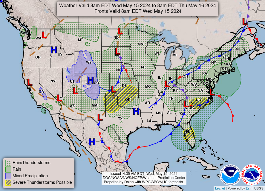
NOAA Forecast Map for Tomorrow


Forecast Map for Tomorrow
Forecast map for Today courtesy of NOAA. Forecast map for Tomorrow courtesy of NOAA.

Random Weather Facts

Recycling
We use over 80,000,000,000 aluminum soda cans every year.

Today in Weather History

Weather History for May 16
 
1952
High winds in the Wasatch Canyon of Utah struck Ogden and Brigham City. Winds at Hill Air Force Base gusted to 92 mph. (The Weather Channel)

1988
Afternoon and evening thunderstorms developing ahead of a cold front produced severe weather from Florida to New York State. Unseasonably warm weather prevailed in the north central U.S. Havre, MT, reported a record high of 95 degrees. (The National Weather Summary)