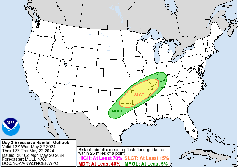
WPC Excessive Rainfall Outlook Day 3
Images courtesy of the NWS Weather Prediction Center
| Excessive Rainfall Forecast Discussion |
Excessive Rainfall Discussion
000
FOUS30 KWBC 300054
QPFERD

Excessive Rainfall Discussion
NWS Weather Prediction Center College Park MD
854 PM EDT Mon Apr 29 2024

Day 1
Valid 01Z Tue Apr 30 2024 - 12Z Tue Apr 30 2024

...THERE IS A MARGINAL RISK OF EXCESSIVE RAINFALL ACROSS THE
SOUTHWESTERN MOST OHIO VALLEY SOUTHWARD TO MIDDLE GULF COAST...

A slow-moving cold front will continue to move overnight with a
modest convergence signal over the southwestern reaches of the Ohio
Valley southward to the Middle Gulf coast.  into the Lower to Mid
Mississippi. The Mid- South region is between two main upper level
disturbances...one moving across parts of Arkansas and evidence of
a second lifting northwards towards the western Great Lakes. The
Tennessee Valley potentially will have less forward propagation
and better upper level diffluence/divergence ahead of the incoming
cold front. The atmosphere ahead of the front has a decent theta-E
ridge in place over much of the Tennessee and Ohio Valleys and
precipitable water values nearly 2 deviations above climatology for
this time of year...so any convective development may be able to
produce locally heavy rainfall within the corridors of interest.
With loss of daytime heating...isolated maximum amounts of 3 inches
are possible within a broader 1 to 2 inch area of rainfall. The
location of heaviest rainfall in the guidance has shifted east from
earlier in the day and away from lower flash flood guidance...so
maintaining a Marginal Risk. Rainfall elsewhere is expected to have
less instability to work with and have greater forward
propagation, so a large Marginal Risk remains to deal with the
possibilities there.

Bann


Day 2
Valid 12Z Tue Apr 30 2024 - 12Z Wed May 01 2024

...A MARGINAL RISK OF EXCESSIVE RAINFALL EXISTS ACROSS PORTIONS OF
THE SOUTHERN PLAINS, MIDWEST, UPPER MISSISSIPPI VALLEY, AND IN AND
NEAR PORTIONS OF THE APPALACHIANS...

...Northeast...
The Marginal Risk was maintained across PA/NY state with some
expansion into VT thanks to marginal convective risk coupling with
some wetter antecedent conditions that arose from the previous day
of rainfall. A west-east situated stationary boundary will remain
draped across Upstate NY through into the adjacent Ontario Province
with a cold front progressing across the Great Lakes and Ohio
Valley into the Northeastern US. Elevated PWAT signatures extending
up through the eastern CONUS will enhance the environment capable
of producing some locally heavy rainfall on Tuesday afternoon and
evening as the aforementioned cold front approaches and provides a
decent convergence pattern across the Northern Mid-Atlantic into
parts of New England. The flow will be progressive in nature, the
max potential is capped with HREF probability fields capping hourly
rates to between 1-2"/hr with 1"/hr still very promising over
western NY once convective initiates (50-70%). This will be enough
to cause some localized flooding within the terrain extending
through the northern Hudson up through the Adirondacks with the
northern extent situated over into VT and the southern edge over
central PA. The combination of low-level convergence and ascent
from an approaching shortwave is best suited over NY state with the
northern and southern periphery approaching the lower end of the
MRGL threshold as the upper ascent pattern will be the primary
driver for each respective location. A max of 2-3" will be forecast
across a few areas in NY, but the general consensus is 0.5-1.5"
for the rest of the areas impacted. This was sufficient for the
MRGL risk to be maintained.

...Upper Ohio/Tennessee Valleys into the adjacent Appalachians...
Some degree of overnight showers and thunderstorms is expected to
continue into Tuesday morning from KY into TN, south and east of a
cold front approaching from the west. It`s not clear if storms
lingering into Tuesday morning from the overnight will pose a flash
flood concern but some redevelopment of convection is likely
during the afternoon hours. Moisture anomalies are forecast to
decrease during the day as an upper trough passes by overhead, but
a small window for localized flash flooding appears possible prior
to winds shifting around to the northwest near/after 00Z.

...Midwest to Upper Mississippi Valley...
A quick-moving shortwave will eject out of the southern periphery
of a negatively tilted longwave trough over the northern Plains
and southern Canada leading to convective genesis over the northern
and central plains. The synoptic evolution has gained consensus
from the latest deterministic suite which has allowed for some
general agreement amongst the ensembles during the Tuesday evening
time frame. The guidance has a signal for local 2-4" amounts but a
great deal of deterministic spread remains. Kept the risk level as
Marginal for the time being, but Slight Risk impacts can`t be ruled
out on a localized basis.

...Southern to Central Plains...
Increasing southerly flow thanks to the development of a surface cyclone
over the northern Plains, advection of elevated theta-E`s and associated
instability occurs within the confines of central and eastern KS on
Tuesday afternoon. A cold front will strengthen along the tail end of
the surface low and progress eastward allowing for a developing surface
convergence pattern in-of the central plains. Large scale forcing from
a progressive shortwave on the tail end of a broad, negatively tilted
longwave trough will act in tandem with the surface to create a locally
dynamic convective regime within the northern periphery of our theta-E
ridge. Best prospects for convection remain over southeast KS with localized
totals up to 5" possible. Hourly rain totals of 1.5"/hr are possible
based on the ingredients available. For the moment, the signal
appears to be small enough and there is some dispersion in the
guidance, enough to preclude an upgrade. Nevertheless, due to wet
antecedent conditions, Slight to Moderate Risk impacts on a
localized basis can`t be ruled out.

A threat for flash flooding will exist over OK into northern and
west TX as convection tries to fire over the dryline positioned
from the TX Big Bend up through OK. A lot of the convective threat
is conditional in nature, but the moisture and instability are
present and more than capable of some heavier rains within any
convection that does develop. It will come down to whether a small
mid-level perturbation ripples through the flow and allows for
enough mid-level ascent to help ignite the convection within the
confines of the boundary. Hourly amounts to 2" and local amounts to
4" are possible here.

Roth/Kleebauer


Day 3
Valid 12Z Wed May 01 2024 - 12Z Thu May 02 2024

...A SLIGHT RISK OF EXCESSIVE RAINFALL IS FORECAST OVER PORTIONS OF
THE MIDWEST & CENTRAL/SOUTHERN PLAINS...

Midwest/Central Plains...
A broad, closed upper level cyclone will persist over eastern MT
into the adjacent northern plains and southern Canadian Provinces
by Wednesday with a potent, mid-level shortwave rounding the base
of the mean trough and exiting into the northern high plains by the
second half of the period. A vigorous upper diffluent pattern will
transpire by Wednesday afternoon and evening with a corridor of
convection initiating towards nightfall. A stout LLJ will enhance
areal shear in-of the central and northern plains within the Quad
state area between NE/KS/IA/MO. Any convective development will
congeal and grow upscale into a large cluster of heavy
thunderstorms within the above area leading to widespread heavy
rains capable of flash flooding as rates likely reach towards that
1-2"/hr marker with locally higher possible. QPF maximum of over 3"
is likely given the setup which would create the threat approaching
the elevated side of the SLGT risk thanks to wet antecedent
conditions from prior rainfall expected to reduce FFG indices, but
spread on amounts and locations remains too large to consider a
Moderate Risk for the time being. Moderate Risk impacts are
certainly possible.


Southern Plains...
The location on a secondary rainfall maximum across TX is becoming more
clear as a quick moving shortwave embedded within the subtropical jet
ejects out of MX and moves to the northeast by Wednesday evening. Guidance
suggests that somewhere across eastern TX would be the primary target
for convective development with the heaviest rainfall located within
the tongue of higher theta-E`s positioned east of the line from ABI
to DRT. The 12z Canadian Regional guidance was very aggressive on
amounts, with locations similar to the heavy rainfall experiencing
another 10"+ of rain. Considering the ML output remaining steadfast
from the past succession of runs, the Red River into the TX Hill
Country and points east will likely see some flare up of
thunderstorms with a deep, moist convective pattern capable of
enhanced rainfall rates typical with flooding. Should the guidance
converge further with similar amounts, a Moderate Risk cannot be
ruled out in later issuances. Moderate Risk impacts are certainly
possible wherever the heavy rainfall materializes.

Roth/Kleebauer

Day 1 threat area: https://www.wpc.ncep.noaa.gov/qpf/94epoints.txt
Day 2 threat area: https://www.wpc.ncep.noaa.gov/qpf/98epoints.txt
Day 3 threat area: https://www.wpc.ncep.noaa.gov/qpf/99epoints.txt


