RSS Mesoscale Discussions from Storm Prediction Center
WW 135 SEVERE TSTM OK TX 260235Z - 260900Z
URGENT - IMMEDIATE BROADCAST REQUESTED
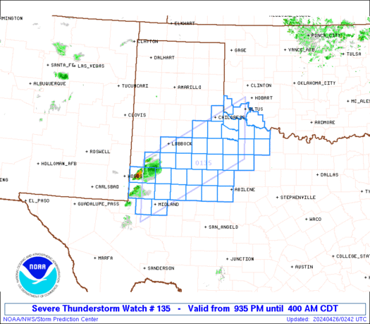
Severe Thunderstorm Watch Number 135
NWS Storm Prediction Center Norman OK
935 PM CDT Thu Apr 25 2024
The NWS Storm Prediction Center has issued a
* Severe Thunderstorm Watch for portions of
Southwestern Oklahoma
West and northwest Texas
* Effective this Thursday night and Friday morning from 935 PM
until 400 AM CDT.
* Primary threats include...
Scattered large hail and isolated very large hail events to 3
inches in diameter likely
Scattered damaging winds likely with isolated significant gusts
to 75 mph possible
A tornado or two possible
SUMMARY...Thunderstorms initially developing near the TX/NM line
over the Permian Basin/South Plains region should move northeastward
and evolve into an organized cluster or complex. Large to very
large hail and sporadic severe gusts are possible the first few
hours, transitioning to more of an organized wind threat with
isolated large hail. A tornado or two also may occur.
The severe thunderstorm watch area is approximately along and 60
statute miles north and south of a line from 35 miles northwest of
Midland TX to 35 miles south of Altus OK. For a complete depiction
of the watch see the associated watch outline update (WOUS64 KWNS
WOU5).
PRECAUTIONARY/PREPAREDNESS ACTIONS...
REMEMBER...A Severe Thunderstorm Watch means conditions are
favorable for severe thunderstorms in and close to the watch area.
Persons in these areas should be on the lookout for threatening
weather conditions and listen for later statements and possible
warnings. Severe thunderstorms can and occasionally do produce
tornadoes.
&&
OTHER WATCH INFORMATION...CONTINUE...WW 133...
AVIATION...A few severe thunderstorms with hail surface and aloft to
3 inches. Extreme turbulence and surface wind gusts to 65 knots. A
few cumulonimbi with maximum tops to 550. Mean storm motion vector
23045.
...Edwards
Read more
WW 0136 Status Updates
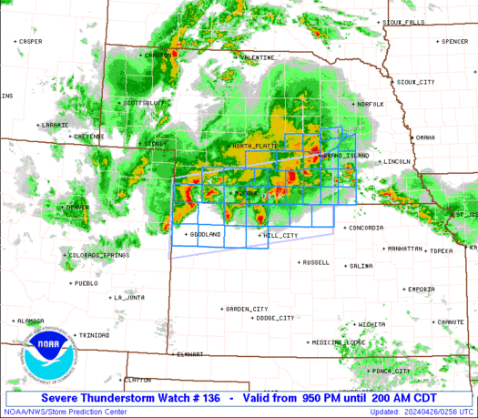
STATUS REPORT ON WW 136
SEVERE WEATHER THREAT CONTINUES RIGHT OF A LINE FROM 15 NE HLC TO
35 NNE HLC TO 10 WSW MCK TO 25 ENE IML.
..GOSS..04/26/24
ATTN...WFO...GLD...GID...LBF...
STATUS REPORT FOR WS 136
SEVERE WEATHER THREAT CONTINUES FOR THE FOLLOWING AREAS
KSC089-147-183-260540-
KS
. KANSAS COUNTIES INCLUDED ARE
JEWELL PHILLIPS SMITH
NEC001-019-035-047-059-061-063-065-073-079-081-083-085-093-099-
121-125-129-137-143-145-163-169-181-185-260540-
NE
. NEBRASKA COUNTIES INCLUDED ARE
ADAMS BUFFALO CLAY
DAWSON FILLMORE FRANKLIN
FRONTIER FURNAS GOSPER
HALL HAMILTON HARLAN
HAYES HOWARD KEARNEY
MERRICK NANCE NUCKOLLS
PHELPS POLK RED WILLOW
SHERMAN THAYER WEBSTER
YORK
Read more
WW 0135 Status Updates


STATUS REPORT ON WW 135

SEVERE WEATHER THREAT CONTINUES RIGHT OF A LINE FROM 30 WSW ABI
TO 75 NW ABI TO 55 S CDS TO 10 NE LTS.

FOR ADDITIONAL INFORMATION SEE MESOSCALE DISCUSSION 0522

..THORNTON..04/26/24

ATTN...WFO...OUN...MAF...LUB...SJT...


STATUS REPORT FOR WS 135

SEVERE WEATHER THREAT CONTINUES FOR THE FOLLOWING AREAS

OKC065-141-260840-

OK
.    OKLAHOMA COUNTIES INCLUDED ARE

JACKSON              TILLMAN


TXC009-023-207-253-275-433-441-447-485-487-260840-

TX
.    TEXAS COUNTIES INCLUDED ARE

ARCHER               BAYLOR              HASKELL
JONES                KNOX                STONEWALL
TAYLOR               THROCKMORTON        WICHITA
WILBARGER


THE WATCH STATUS MESSAGE IS FOR GUIDANCE PURPOSES ONLY.  PLEASE
REFER TO WATCH COUNTY NOTIFICATION STATEMENTS FOR OFFICIAL
INFORMATION ON COUNTIES...INDEPENDENT CITIES AND MARINE ZONES
CLEARED FROM SEVERE THUNDERSTORM AND TORNADO WATCHES.

Read more